Displaying 1 - 4 of 4
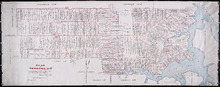
Plan of Township No. 6: Compiled from plans, leases, deeds, and other documents on file in the Land…
Description: The map shows Lot 6 divided into parcels of land with names of residents, their acreage amounts and land conveyance references handwritten in black and red ink. Shows the P.E.I. Railway in red, roads… more
Province: PE
Type: cadastral maps
Date Created: 1912-01

Plan of Township No. 6: Compiled from plans, leases, deeds, and other documents on file in the Land…
Description: The map shows Lot 6 divided into parcels of land with names of residents, their acreage amounts and land conveyance references handwritten in black and red ink. Shows the P.E.I. Railway in red, roads… more
Province: Prince Edward Island
Type: cadastral maps
Date Created: 1912-01
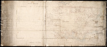
Plan of Lot or Township No. 6 in Prince Edward Island: From Actual Survey by A. Anderson, Land…
Description: Plan of Lot 6. Northern half shows residents.
Province: Prince Edward Island
Type: cadastral maps

Plan of Lot Six: Prince Co., P.E.I.
Description: Map showing lot six, bordering lots 5, 9, 10, 11 in Prince county. Shows rivers, creeks, railroads, roads, landowners, acreage, post offices, and buildings. Geographical compass
Publisher: J. H. Meacham & company
Province: Prince Edward Island
Type: cadastral maps
Date Issued (Source): 1880