Displaying 1 - 4 of 4

Plan of Lot or Township No. 39: from the lastest Surveys by Joseph Ball, S.G., July 1, 1857
Description: Plan of Lot 39 (No.104). Worrell Estate. Plan copied by Owen Curtis, 1876.
Province: Prince Edward Island
Type: cadastral maps
Date Created: 1857-07-01
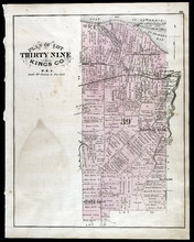
Plan of Lot Thirty Nine: Kings Co., P.E.I.
Description: The map shows lot 39 in Kings county. Shown are a gulf, lake, sand, light house, post offices, landowners and acreage, roads, railroads and stations, rivers, school houses, churches, and an Indian… more
Publisher: J. H. Meacham & company
Province: Prince Edward Island
Type: cadastral maps
Date Issued (Source): 1880
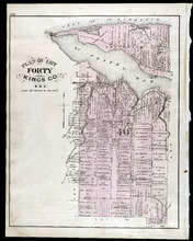
Plan of Lot Fourty: Kings Co., P.E.I.
Description: The map shows Lot 40 in Kings county. Shown are a bay, gulf, river, ponds, school house, churches, wharf, post office, roads, landowners and acreage, and mills. Compass.
Publisher: J. H. Meacham & company
Province: Prince Edward Island
Type: cadastral maps
Date Issued (Source): 1880
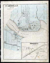
Cardigan Lot 53: Morrell Lot 40
Description: The map shows lot 53 in Cardigan. Shown are a river, roads, railroads, lots, landowners, school house, buildings, houses, wharfs and creeks. Compass.
Publisher: J. H. Meacham & company
Province: Prince Edward Island
Type: cadastral maps
Date Issued (Source): 1880