Displaying 1 - 3 of 3
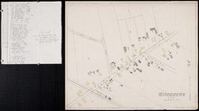
Miscouche, Lot 17
Description: This item consists of a fire insurance plan of the community of Miscouche and an accompanying handwritten text document. The map of Miscouche focuses on the area of the Fifteen Point Road. It shows… more
Province: Prince Edward Island
Type: fire insurance maps
Date Issued (Source): 1888
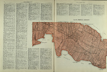
Lot 17: Prince County
Description: The map shows Lot 17 in Prince county. Shown are byas, coves, landowners, acreage, towns, cities, and roads.
Publisher: Cummins Map Co.
Province: Prince Edward Island
Type: cadastral maps
Date Issued (Source): 1927

Plan of Lot Seventeen: Prince Co., P.E.I.
Description: The map shows lot 17 along with two smaller maps of lot 17 and 23. The map includes landowners and acreage, railroads and stations, roads, districts, creeks, rivers, bays, marshes, brooks, coves,… more
Publisher: J. H. Meacham & company
Province: Prince Edward Island
Type: cadastral maps
Date Issued (Source): 1880