Displaying 1 - 2 of 2
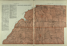
Lots 29 and 30: Queens County
Description: The map shows lots 29 and 30 in Queens county. Shown are roads, landowners, acreage, the Northumberland Strait, Westmoreland Harbour, and Sable River.
Publisher: Cummins Map Co.
Province: Prince Edward Island
Type: cadastral maps
Date Issued (Source): 1927

Plan of Lot Twenty Seven: Prince Co., P.E.I.
Description: The map shows lot 27 in Prince county. The map shows roads, railroads, crosses, ponds, rivers, bays, straits, coves, mills, post offices, and churhces. Graphic compass.
Publisher: J. H. Meacham & company
Province: Prince Edward Island
Type: cadastral maps
Date Issued (Source): 1880