IslandImagined
Historic Maps of PEI
Menu
Main navigation
Search
Map Archive
Map Archive sub-navigation
All Maps
... by County
Prince
Queens
Kings
... by Type
Boundary Maps
Cadastral Maps
Chorographic Maps
Fire Insurance Maps
Historical Atlases
Plans
Topographic Maps
Atlases
Cummins Atlas - 1928
Roe Brothers Atlas - 1878
Meacham's Atlas - 1880
Interactive
Interactive sub-navigation
Map Timeline
GeoPEI Map Viewer
Learn More
Learn More sub-navigation
FAQ
Learning Guides
Articles
Online Books
Glossary
Contact
Breadcrumb
Home
Search Content
Displaying 1 - 1 of 1
Results per page
27
54
108
Sort
Relevance β
Relevance β
Title β
Title β
Year β
Year β
Displaying 1 - 1 of 1
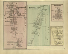
Hillsborough : Hopewell Cape : Salisbury : Hopewell Corner
Description:
The map shows Hillsborough. Shown are buildings, lots, landowners, districts, Mill creek, wharfs, railways, post offices and shops. The map shows Hopewell Cape. Shown are buildings, landowners, roadsβ¦
more
Publisher:
Roe Brothers
Province:
New Brunswick
Type:
geographical maps
Date Issued (Source):
1878