Displaying 1 - 6 of 6
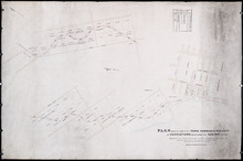
Plan Shewing Lands in the Town, Common, and Royalty of Georgetown appropriated for Railway purposes…
Description: Plan showing lands in the Town, Common, and Royalty of Georgetown appropriated for Railway Purposes. The map shows residents, acreage, roads, and harbours.
Province: Prince Edward Island
Type: cadastral maps

Tracing of the right of way for the Prince Edward Island Railway into Georgetown.
Description: Tracing of the right of way for the Prince Edward Island Railway into Georgetown.
Province: Prince Edward Island
Type: cadastral maps

Plan of Georgetown, Georgetown Common, and Georgetown Royalty
Description: Plan of Georgetown, Georgetown Common, and Georgetown Royalty. Shows lot numbers. Gives names of a few residents in the Royalty. Also gives nautical soundings for Albion Bay and Brudenell River.
Province: Prince Edward Island
Type: cadastral maps
Date Created: 1828
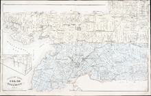
Plan of Lots 49 & 50: Queens Co., P.E.I.
Description: The map shows lot 49 & 50 in Queens County. Shown are roads, landowners and acreage, lakes, bays, coves, wharfs, post offices, churches, and schools. Graphic compass
Publisher: J. H. Meacham & company
Province: Prince Edward Island
Type: cadastral maps
Date Issued (Source): 1880
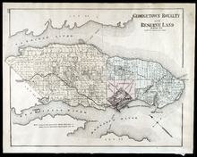
Georgetown Royalty and Reserve Land: Kings Co., P.E.I.
Description: The map shows Georgetown Royalty and Reserve Land in Kings county. Shown are rivers, roads, railroads and stations, landowners and acreage, beaches, Georgetown commons, square, market, court house,… more
Publisher: J. H. Meacham & company
Province: Prince Edward Island
Type: cadastral maps
Date Issued (Source): 1880
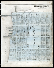
Georgetown: Kings Co., P.E.I.
Description: The map shows Georgetown in Kings county. Shown are wharfs, harbour, roads and streets, railroads and stations, landowners, houses, court house, scholl house, drill shed, Georgetown square, churches… more
Publisher: J. H. Meacham & company
Province: Prince Edward Island
Type: cadastral maps
Date Issued (Source): 1880