Displaying 1 - 7 of 7

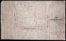
Common Lot No 21 as divided into Building Lots
Description: Plan of Common Lot No.21. Charlottetown as divided into building lots. (No.380) The map shows lots, acreage and roads/streets.
Province: Prince Edward Island
Type: cadastral maps
Date Created: 1872-08
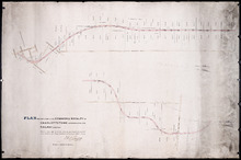
P.E.Island Railway: Charlottetown
Description: Prince Edward Island Railway. Charlottetown. Appropriations into Charlottetown Station. The map shows roads, streets, lots, and buildings.
Province: Prince Edward Island
Type: plans
Date Created: 1871

Plan Shewing lands in Charlottetown Appropriated fro Railway purposes : The Figures 67 &c.…
Description: Plan showing lands in Charlottetown appropriated for Railway purposes. The map shows lots, residents, streets, and wharfs.
Province: Prince Edward Island
Type: cadastral maps
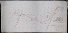
Plan Shewing Lands in the Common and Royalty of Charlottetown appropriated for Railway purposes.
Description: Plan showing land in the Common and Royalty of Charlottetown appropriated for Railway purposes. The map shows lots, acreage, roads, cities and towns.
Province: Prince Edward Island
Type: cadastral maps
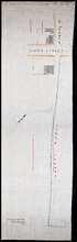
Plan of part of Charlottetown showing Pownal Wharf and Lot No.5
Description: Plan of part of Charlottetown showing Pownal Wharf and part of Town Lot No.5 located in 1st Hund. Also shown are buildings and wharfs.
Province: Prince Edward Island
Date Created: 1868-08

Plan of Right of Way as on the Ground part of Town Lot No. 36 in the 4th Hund. Charlottetown.
Description: Plan of the Right of Way through Town Lot No.36 in the 4th Hundred in Charlottetown. (No.40). The map shows Kent Street and landowners.
Province: Prince Edward Island
Type: cadastral maps
Date Created: 1898-06
Part of Common Lot No. 22.
Description: Plan of part of Common Lot No.22, Charlottetown.
Province: Prince Edward Island
Type: cadastral maps
Date Created: 1886