Displaying 1 - 8 of 8
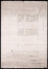
Plan of part of Town Lots Nos. 54 and 55, and Nos. 91 and 92 in the 2nd Hundred of Town Lots in…
Description: Plan of part of Town Lots Nos. 54 and 55, and Nos. 91 and 92 in the 2nd Hundred of Town Lots in Charlottetown agreeably to the possession of the Misses Stewart according to the original survey of the… more
Province: Prince Edward Island
Type: cadastral maps
Date Created: 1860-07-25

Plan Shewing the Eligible Situation of Acre Lots on the Estate of the Honble. J. C. Pope. in the…
Description: Plan showing the eligible situation of acre lots on the estate of Hon. J.C. Pope in the Royalty of the city of Charlottetown. Royalty Lots No.85, No.95 and No.97. (No.386)
Province: Prince Edward Island
Type: cadastral maps
Date Created: 1878
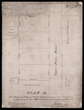
Plan A. Of 4 Pleasantly Situated Building Lots, fronting on Upper Prince Street, The property of…
Description: Plan "A" of four pleasantly situated lots fronting on Upper Prince Street, the property of the Hon. T.H. Haviland, Common Lot No.24. (No.60) more
Province: Prince Edward Island
Type: cadastral maps
Date Created: 1886

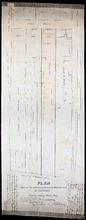
Plan of St. Avard's divided into Building Lots part of the Estate of the Honble. James C. Pope…
Description: Plan of St. Avards divided into building lots, part of the estate of the Hon. James C. Pope in the Royalty of Charlottetown. Royalty Lot No.13. Also shown are St. Peters Road, and Mt. Stewart Road.
Province: Prince Edward Island
Type: cadastral maps
Date Created: 1878

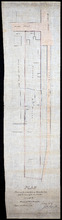
Plan showing the situation of part of the Estate of the late Owen Connolly Esq. in Charlottetown…
Description: Plan showing the situation of part of the Estate of the late Owen Connolly in Charlottetown Common and Royalty. Created by John Ball, surveyor, and copied by Thomas W. May. The map shows Malpeque… more
Province: Prince Edward Island
Type: cadastral maps
Date Created: 1921-01
Plan Shewing the situation of that part of Water Lot No. 7. at Charlottetown Sold to Henry Beer Esq.
Description: Plan showing the situation of that part of Water Lot No.7 at Charlottetown sold to Henry Beer. (No.26) (Also No.216 Queens County). The map shows streets such as Great George, Prince, Water, wharfs,… more
Province: Prince Edward Island
Type: cadastral maps
Date Created: 1881
Plan Shewing the situation of Water Lot No. 8, and that part of Water Lot No. 7 conveyed to Ronald…
Description: Plan showing the situation of Water Lot No.8 and that part of Water Lot No.7 conveyed to Ronald MacMillan. The map also shows streets such as Water street, Prince, lots, Ferry Wharf, and Hillsborough… more
Province: Prince Edward Island
Type: cadastral maps
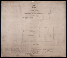
No. 3 Plan of a Tract of Land Appropriated by the Commissioners of the Water-works of Charlottetown
Description: Plan of a tract of land in Charlottetown Royalty appropriated by the Commissioners of the Water-works of Charlottetown. (No.3) (Also No.104). Also shown are landowners and acreage.
Province: Prince Edward Island
Type: cadastral maps