Displaying 1 - 4 of 4
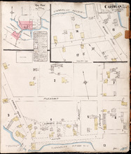
Cardigan P.E.I., Kings Co.: Population 300. No Protection. Oct. 1910
Description: This is a fire insurance plan of the village of Cardigan consisting of two maps--one for each side of the Cardigan River. A key plan in the upper left corner provides context. The map on the upper… more
Publisher: Chas. E. Goad, Civil Engineer
Province: Prince Edward Island
Type: fire insurance maps
Date Created: 1910-10
Date Issued (Source): 1888
Date Modified (Source): 1910-10, 1917-10
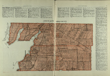
Lots 53 and 54: Kings County
Description: The map shows lots 53 and 54 in Kings county. Shown are bays, rivers, an Indian marsh, landowners, acreage, roads, and railroads.
Publisher: Cummins Map Co.
Province: Prince Edward Island
Date Issued (Source): 1927
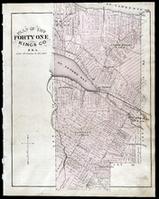
Plan of Lot Forty One: Kings Co., P.E.I.
Description: The map shows lot 41 in Kings county. Shown are St. Peters bay, river, gulf, roads, landowners and acreage, railroad and station, post offices, mills, schools, and churches. Compass.
Publisher: J. H. Meacham & company
Province: Prince Edward Island
Type: cadastral maps
Date Issued (Source): 1880
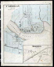
Cardigan Lot 53: Morrell Lot 40
Description: The map shows lot 53 in Cardigan. Shown are a river, roads, railroads, lots, landowners, school house, buildings, houses, wharfs and creeks. Compass.
Publisher: J. H. Meacham & company
Province: Prince Edward Island
Type: cadastral maps
Date Issued (Source): 1880