| Title Proper |
Atlas of the Maritime Provinces of the Dominion of Canada with historical and geological descriptions
|
|---|---|
| Subtitle |
drawn on the rectangular polyconic projection from the British Admiralty charts, the National Boundary Survey, official plans, railway surveys, latest and most reliable maps, and new surveys made by the Authors
|
| Access Condition |
This material is provided for research, education, and private use only.
|
| Type | |
| Physical Location |
Robertson Library, UPEI
|
| Contributors |
Cartographer: Roe Brothers
|
| Date Issued |
1878
|
| Publisher |
Roe Brothers
|
| Extent |
99 p. : ill. ; 34 cm.
|
| Subject (Geographic) |
Atlas of the Maritime Provinces of the Dominion of Canada with historical and geological descriptions
In this collection
Displaying 28 - 37 of 37
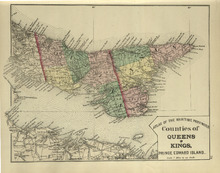
Counties of Queens and Kings: Prince Edward Island
Description: The map shows the counties of Queens and Kings in Prince Edward Island. Shown are bays, points, rivers, capes, coves, harbours, roads, railroads, cities, and towns.
Province: Prince Edward Island
Type: geological maps
Date Issued (Source): 1878
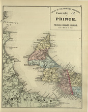
County of Prince: Prince Edward Island
Description: The map shows the county of Prince in Prince Edward Island. Shown are capes, bays, coves, roads, railroads, cities and towns.
Province: Prince Edward Island
Type: geological maps
Date Issued (Source): 1878
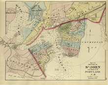
Map of the City of St. John and Town of Portland: N.B.
Description: The map shows the City of St. John and Town of Portland in New Brunswick. Shown are bays, rivers, harbour, lots, acreage, roads, railroads, towns, buildings, and names.
Province: New Brunswick
Type: geological maps
Date Issued (Source): 1878
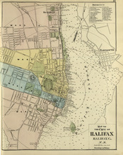
Map of the City of Halifax: Halifax Co. N.S.
Description: The map shows the city of Halifax, Halifax County in Nova Scotia. Shown are a Reference table, Halifax Harbour, pond, roads, wards, lots, buildings, and landowners.
Province: Nova Scotia
Type: geographical maps
Date Issued (Source): 1878
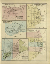
Chatham : Charlottetown : New Castle : City of Fredricton : Moncton: Northumberland Co. N.B..…
Description: The map shows Catham in the Northumberland county. New Brunswick. Shown are a river, wharf, streets, buildings, lots and a ferry crossing. The map shows Charlottetown in Queens county, Prince Edward… more
Province: New Brunswick, Prince Edward Island
Type: geographical maps
Date Issued (Source): 1878
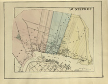
St. Stephen
Description: The map shows St. Stephen. Shown are a railroad and station, lots, wards, roads, buildings, and St. Croix River.
Province: New Brunswick
Type: geographical maps
Date Issued (Source): 1878
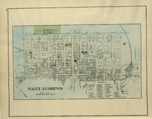
St. Andrews
Description: The map of St. Andrews. Shown are a Reference table, railroads and station, military lands, roads, lots, owners, and wharfs.
Province: New Brunswick
Type: geographical maps
Date Issued (Source): 1878
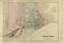
Moncton
Description: The map shows Moncton. Shown are a References table, wards, roads, railways and station, lots, buildings, landowners, and Petitcodiac River.
Province: New Brunswick
Type: geographical maps
Date Issued (Source): 1878
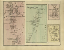
Hillsborough : Hopewell Cape : Salisbury : Hopewell Corner
Description: The map shows Hillsborough. Shown are buildings, lots, landowners, districts, Mill creek, wharfs, railways, post offices and shops. The map shows Hopewell Cape. Shown are buildings, landowners, roads… more
Province: New Brunswick
Type: geographical maps
Date Issued (Source): 1878
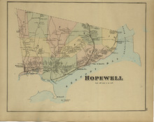
Hopewell
Description: The map shows Hopewell. Shown are a bay, island, rivers, wharf, railway and station, roads, landowners, and mountains.
Province: New Brunswick
Type: geographical maps
Date Issued (Source): 1878